flagעברית
flagEnglish
3 Rabinovich St., Petah-Tikva, Israel
+972 3 9047744
office@amironic.co.il
Facebook
Twitter
LinkedIn
YouTube
  • Products
    • MEMS Inertial
      • Gyros & Accels
      • IMU
      • Inertial Navigation
      • AHRS
    • Circuit Breakers
      • Airpax Circuit Breakers
      • Electronic Circuit Breakers
      • Aircraft Circuit Breakers
      • Thermal Circuit Breakers
      • Sealing Solutions & Guards
    • Footswitches
      • Pedals & Bellows
      • USB
      • Air Switches
      • Medical
      • Modular Bases System
      • Industrial
      • Foot Potentiometers
      • Wireless
    • Mechanical & Transmisions
      • Gears
      • Sealing Solutions
      • Gearboxes
      • Couplings
      • Shafts & Bearings
      • Fasteners
      • Mechanical & Springs
      • Linear Motion
      • Anti-Vibration
    • Sensors
      • Thermostats
      • Temperature
      • Position
      • Pressure
      • Speed
      • Level Sensor
      • Load Cells
      • Flex Sensors
      • Membrane Potentiometer
    • Motors
      • Geared DC
      • Brushless DC
      • Step Motors with Gearbox
      • Torque Motors & Brushless Servo
      • DC Motors
    • Electronics
      • Xenon & IR Lamps
      • Counters & Meters
      • Microelectronics Packaging
      • Waterproof Switches
      • Micro Switches
    • Hand Control
      • Operator Controls (JOYSTICK)
      • Electrical
      • Pneumatic (Medical)
      • USB Hand Control
      • Air Push Button
      • Pressure Switch
      • IR Switch
    • Power Solutions
      • Rugged & Military Power Supply
      • Input Power Protection
      • Sealed Military Power Adaptor
      • Triple Output Military Power Supply Series – up to 250 W
    • Materials
      • Molybdenum and Advanced Alloys (TZM, MOLA, HCT)
      • Tungsten (Wolfram) and Advanced Alloys – High-Performance Materials for Extreme Conditions
      • Materials for Gears
  • Shop
  • Companies
  • About Amironic
  • News
  • Contact
Product was added to your cart

Cart

waze

When GPS Lies: Why IMUs Are Becoming Mission-Critical in the Era of Autonomous Wingmen

MEMS Inertial04/08/2026amironicLTD

In recent years, a new operational concept has been reshaping the aerospace industry. Instead of relying on a single aircraft to perform an entire mission, more and more systems are being designed to operate as coordinated teams consisting of a crewed platform alongside multiple autonomous aircraft.

These autonomous platforms are far more than simple followers. They may perform different tasks simultaneously, maintain formation, gather information from multiple locations, and exchange data in real time. Each platform makes its own decisions while continuing to operate as part of a coordinated system.

As the number of autonomous platforms increases, so does the importance of precise and reliable navigation.

Every aircraft must continuously know:

  • Where it is.
  • Which direction it is moving.
  • Its current speed.
  • The location of the other platforms in the formation.
  • How to maintain proper spacing and coordination.

As long as the GNSS data is reliable, the mission appears relatively straightforward.

But what happens when the GNSS receiver doesn’t stop working – it simply starts providing incorrect information?

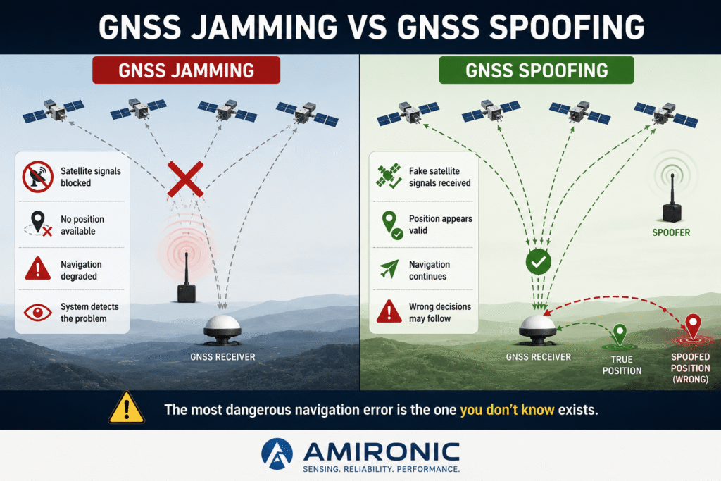
When GNSS signals are jammed, the navigation system typically detects the loss of signal and can switch to an alternative navigation mode. In contrast, during a GNSS spoofing attack, the receiver continues to receive signals that appear completely valid, while the calculated position, velocity, or timing no longer reflects reality.

The greatest challenge is that the system may not realize the information is incorrect.

It continues making decisions based on data that appears trustworthy but has actually been manipulated.

When multiple autonomous aircraft operate together, an error affecting just one platform can disrupt the coordination of the entire formation.

This is precisely where Inertial Measurement Units (IMUs) become essential. While GNSS depends on external satellite signals, an IMU continuously measures the aircraft’s motion independently, providing the flight controller with an additional source of navigation data. This independent information helps identify inconsistencies and enables the system to continue navigating even when GNSS data can no longer be fully trusted.
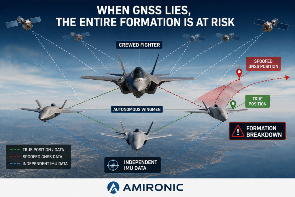
When a navigation system receives incorrect GNSS data, the aircraft may continue to believe it is following the correct flight path. In a formation of multiple autonomous platforms, a navigation error affecting just one aircraft can disrupt the coordination of the entire team.

Not Every GNSS Attack Looks the Same

When discussing threats to satellite navigation systems, most people immediately think of GNSS jamming – disrupting satellite signals by transmitting radio interference. In this scenario, the GNSS receiver struggles or completely fails to calculate its position.

This is certainly a serious problem, but at least the system usually recognizes that something is wrong.

GNSS spoofing, however, is fundamentally different.

Instead of blocking satellite signals, the attacker transmits counterfeit signals that appear completely legitimate to the receiver. From the navigation system’s perspective, the number of visible satellites is normal, signal quality appears excellent, and even the receiver’s health indicators may show that everything is operating correctly.

The problem is that the calculated position, velocity, or timing no longer reflects reality.

In other words, the system has no way of knowing that the information it is receiving is false.

It continues making decisions based on data that appears entirely valid.

For a single aircraft, this may result in a gradual deviation from the planned flight path. However, when multiple autonomous aircraft operate together, each platform relies on this information to maintain its relative position, coordinate mission tasks, and avoid collisions. A navigation error affecting just one platform can influence the behavior of the entire formation.

This is precisely why GNSS spoofing has become one of the most significant challenges in autonomous navigation systems in recent years.

When GNSS stops working, the system knows it must rely on alternative navigation sources. When GNSS continues to provide data that appears valid but is actually incorrect, the challenge becomes far more complex. This is where Sensor Fusion and IMUs become essential, helping the navigation system detect inconsistencies between multiple independent sources of information.

When GNSS Is No Longer the Source of Truth

In modern autonomous systems, the GNSS receiver is not the only sensor on which the flight controller relies.

In practice, the navigation system continuously combines data from multiple sensors, including:

  • IMU (Inertial Measurement Unit)
  • GNSS Receiver
  • Barometer
  • Magnetometer
  • Vision Sensors or Cameras
  • And, depending on the application, LiDAR, Radar, and other sensors

Each sensor provides a different perspective on the aircraft’s motion and environment.

The GNSS receiver provides absolute position and velocity relative to the Earth.

The IMU continuously measures the aircraft’s acceleration and angular rate.

The barometer provides altitude changes.

Vision sensors and cameras estimate movement relative to the ground or surrounding objects.

The flight controller does not blindly trust any single sensor.

Instead, it continuously compares information from all available sources, looking for consistency.

A Simple Example

Imagine the GNSS receiver suddenly reports that the aircraft has accelerated sharply to the right.

At that same moment:

  • The IMU detects no corresponding acceleration.
  • The magnetometer shows no significant change in heading.
  • The vision system detects no unusual movement relative to the ground.

When several independent sensors fail to support the data reported by the GNSS receiver, the system begins to suspect that something is wrong.

This alone does not prove a spoofing attack.

However, it is a strong indication that the navigation system should re-evaluate how much it trusts the GNSS solution.

Sensor Fusion – Not Choosing One Sensor, but Comparing Them All

Sensor Fusion is one of the fundamental building blocks of modern navigation systems.

Rather than relying on a single sensor, the flight controller combines information from multiple independent sources.

When all sensors agree, confidence in the navigation solution remains high.

If one sensor begins to deviate significantly from the others, the system can reduce its weighting in the overall navigation solution or even ignore it temporarily, depending on the system architecture and the fusion algorithm.

This is precisely where the IMU becomes indispensable.

Unlike GNSS, an IMU does not rely on satellites or external radio signals. It continues measuring the aircraft’s motion continuously, even when GNSS signals are blocked, jammed, or spoofed.

As a result, the IMU often becomes one of the primary sources of information used by the navigation system to determine whether the GNSS solution can still be trusted.

Sensor Fusion enables the navigation system to compare information from multiple independent sources. When GNSS data is inconsistent with measurements from the IMU and other onboard sensors, the system can detect the discrepancy and re-evaluate the reliability of the navigation solution.

Why IMU Performance Becomes Mission-Critical

When GNSS data is valid and reliable, the IMU operates as one component of the overall navigation system, contributing acceleration, angular rate, and dynamic motion measurements.

However, the moment the navigation system begins to question the reliability of the GNSS solution, the role of the IMU changes dramatically.

At that point, it is no longer just one sensor among many.

It becomes one of the primary sources of information used by the navigation system.

The more accurate and stable the IMU, the longer the system can continue navigating while maintaining a smaller position error until another trusted navigation source becomes available.

This is precisely why advanced autonomous systems evaluate not only the performance of the GNSS receiver, but also the quality of the inertial navigation system.


Not All IMUs Perform the Same

At first glance, two IMUs may appear nearly identical.

Both measure acceleration and angular rate.

Both provide data at similar update rates.

Both may even be based on the same MEMS technology.

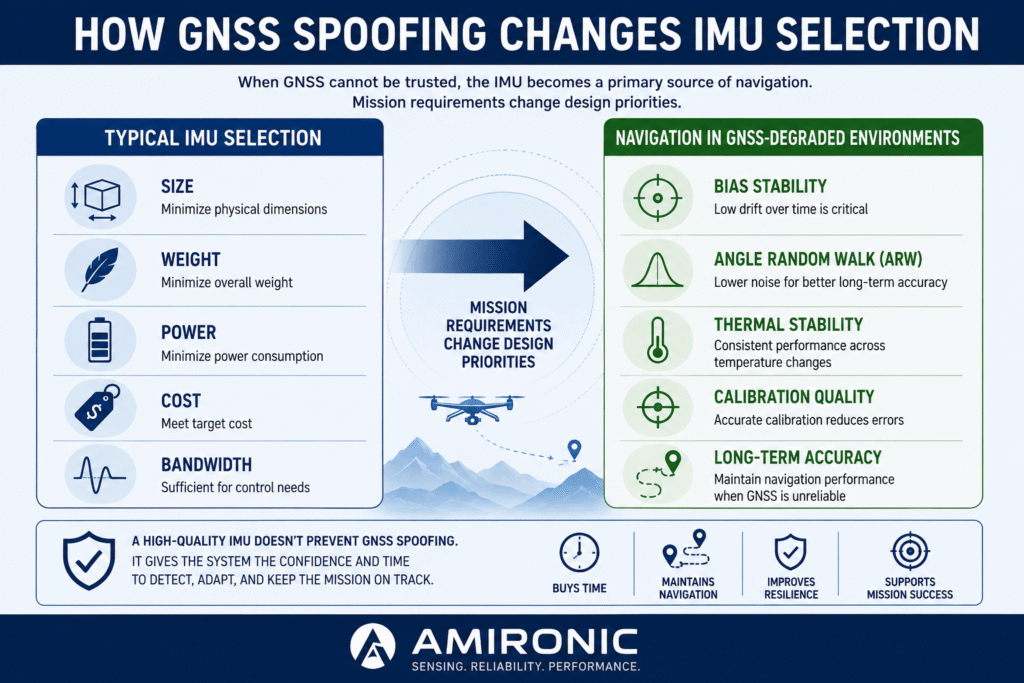
However, once the navigation system is forced to rely more heavily on inertial measurements, the differences between them become significant.

Specifications that often receive little attention during sensor selection suddenly become mission-critical:

  • Bias Stability – How stable the gyroscope and accelerometer bias remains over time.
  • Angle Random Walk (ARW) – The rate at which random sensor noise accumulates and affects angular accuracy.
  • Thermal Stability – The ability to maintain consistent performance across changing temperatures.
  • Calibration Quality – The quality of the calibration process used to compensate for sensor errors and environmental effects.

These parameters do not prevent a GNSS spoofing attack.

Instead, they determine how accurately the navigation system can continue estimating position and attitude while verifying whether the GNSS solution can still be trusted.


The Highest-Performance IMU Is Not Always the Right Choice

One of the most common misconceptions in navigation system design is that selecting the highest-performance IMU automatically leads to the best solution.

In reality, IMU selection is not a competition for the most impressive specifications.

Like every engineering decision, it involves tradeoffs.

A small commercial drone may prioritize low power consumption and minimum weight.

By contrast, an autonomous platform expected to operate in environments where GNSS jamming or spoofing is possible may prioritize long-term stability, even if doing so requires a larger sensor, higher power consumption, or additional cost.

In other words, the real question is not:

“Which IMU is the best?”

The real question is:

“Which IMU delivers the level of performance required for the mission when GNSS can no longer be fully trusted?”

Choosing an IMU is about far more than size, weight, or power consumption. When a system may be exposed to GNSS jamming or GNSS spoofing, parameters such as Bias Stability, Angle Random Walk (ARW), thermal stability, and calibration quality become critical factors in the system’s ability to maintain reliable navigation until the GNSS solution can be verified or restored.

Engineering Example: When a Few Seconds Can Make the Difference

Imagine an autonomous aircraft flying as part of a coordinated formation of multiple platforms.

Midway through the mission, the GNSS receiver begins receiving spoofed satellite signals. From the receiver’s perspective, everything appears normal. Signal quality is high, enough satellites are visible, and no fault is reported.

In reality, however, the calculated position gradually begins to drift away from the aircraft’s true location.

The navigation system now faces a critical decision.

Should it continue trusting the GNSS solution?

Or should it reduce its confidence in the satellite data and rely more heavily on the inertial navigation system?

At this point, IMU performance becomes a decisive factor.

A more stable and accurate IMU enables the navigation system to maintain a reliable estimate of position and attitude for a longer period of time. This gives the Sensor Fusion algorithm valuable time to detect inconsistencies, validate information using other onboard sensors, and make a more informed decision.

In autonomous systems, this additional margin is often measured not in minutes – or even tens of seconds.

Sometimes, just a few extra seconds can make the difference between successfully completing the mission and making critical decisions based on corrupted navigation data.


Engineering Is Always About Tradeoffs

It is tempting to assume that the solution is simply to select the highest-performance IMU available.

In reality, that is not always the right choice.

A compact commercial drone may prioritize minimum weight and low power consumption.

By contrast, an autonomous platform expected to operate in environments where GNSS jamming or spoofing is possible may place greater value on long-term stability, even if that comes at the cost of additional size, weight, or power consumption.

As with any engineering decision, there is no universal solution.

The best IMU is the one that best matches the mission requirements.


0.01°. That’s an angular error far too small for the human eye to notice. Yet at a distance of 12 km, it can already translate into approximately 2 meters of positional error. Increase the error to 0.05°, and the deviation exceeds 10 meters.


What Makes an IMU Suitable for These Applications?

When designing an autonomous system that may operate in GNSS-degraded or GNSS-spoofed environments, the question is not simply whether the system includes an IMU, but whether its performance is sufficient to provide reliable inertial data when confidence in GNSS begins to decline.

A good example is the LandMark™ 006 IMU from Gladiator Technologies, designed specifically for demanding stabilization, navigation, and precision measurement applications.

Its performance characteristics include:

  • Bias Stability: 0.8°/hour, minimizing long-term error accumulation.
  • Angle Random Walk (ARW): 0.0254°/√hr, indicating exceptionally low gyroscope noise.
  • Update Rate: Up to 10 kHz for high-dynamic applications.
  • Bandwidth: Up to 600 Hz, supporting fast stabilization and control loops.
  • Digital Message Delay: Less than 20 µs, minimizing latency in real-time control systems.
  • Full Temperature Calibration: From -50°C to +85°C, ensuring consistent performance across demanding operating conditions.
  • Compact Size: Approximately 17 grams with a volume of just 0.63 in³, making integration possible even in SWaP-constrained platforms.
  • Reliability: MTBF greater than 170,000 hours and a Non-ITAR design suitable for many international programs.

None of these specifications, by themselves, can prevent a GNSS spoofing attack.

However, when low sensor noise, excellent stability, high-quality calibration, wide bandwidth, and extremely low latency are combined, the result is an IMU capable of delivering significantly higher-quality inertial data. Those measurements allow Sensor Fusion algorithms to detect inconsistencies more effectively, maintain navigation continuity, and provide the valuable time needed to make informed decisions when GNSS data can no longer be fully trusted.


When Fractions of a Degree Become Meters

In advanced autonomous systems, even extremely small angular errors can quickly become significant positional errors.

For example, a heading error of just 0.01° can produce approximately 2 meters of deviation at a distance of 12 km. Increase that error to 0.05°, and the deviation exceeds 10 meters.

For navigation, stabilization, and target tracking systems, differences of this magnitude can mean the difference between maintaining an accurate trajectory and accumulating errors that require correction, or between maintaining stable target tracking and losing it altogether.

This is why system designers evaluate much more than the presence of an IMU. Parameters such as Bias Stability, Angle Random Walk, bandwidth, and message latency directly influence the navigation system’s ability to continue making accurate decisions when the reliability of GNSS becomes uncertain.


Introducing the VELOX™ Architecture

Beyond the performance of the sensors themselves, the LandMark™ 006 IMU is built on Gladiator Technologies’ VELOX™ architecture, developed to deliver inertial data at extremely high rates with exceptionally low latency.

The system supports update rates of up to 10 kHz, bandwidths up to 600 Hz, and digital message delays below 20 µs. This combination enables flight control and navigation algorithms to receive highly up-to-date inertial measurements in near real time, even in demanding dynamic applications where every microsecond can influence stabilization, tracking, and control performance.

In addition, VELOX™ Plus supports communication speeds of up to 7.5 Mbaud, enabling rapid data transfer in high-performance embedded systems.

When the navigation system must decide whether to continue trusting GNSS or rely more heavily on inertial measurements, both data quality and data latency become integral to overall system performance.


Conclusion

As autonomous systems become increasingly sophisticated, reliable navigation remains essential even when GNSS signals cannot be fully trusted.

GNSS spoofing demonstrates that a navigation system should not be judged solely by its ability to calculate position, but also by its ability to recognize when the information it receives is no longer reliable.

That is why modern navigation systems combine Sensor Fusion with advanced inertial navigation technology.

An IMU does not replace GNSS, nor can it prevent a spoofing attack.

However, when confidence in GNSS begins to decline, it provides an independent source of motion data that helps maintain navigation continuity, identify inconsistencies, and give the system the time it needs to make better-informed decisions.

Gladiator Technologies has developed tactical MEMS-based IMUs specifically for applications requiring high accuracy, stability, and reliability under demanding operating conditions. For system engineers, the challenge is not selecting the IMU with the most impressive specifications, but choosing the one that delivers the right balance of performance, reliability, and mission suitability.

In an era where GNSS spoofing and navigation deception are becoming operational realities, selecting an IMU is no longer just a component-level decision. It is a system-level decision that directly influences a platform’s ability to navigate, stabilize, and make correct decisions when satellite signals can no longer be trusted.

🧩 Further Reading and Deeper Insight

This article is part of a broader series exploring the engineering principles behind modern inertial sensing and motion stability in advanced control and navigation systems. For deeper technical context and system-level insights, you may also find the following articles valuable:

  • Bridging Control and Navigation: How Advanced MEMS IMUs Are Redefining System Performance
  • Gyro and IMU for Advanced Control Systems
  • The Silent Problem of Precision Systems – Why Gyros and IMUs Are Control Components, Not Just Sensors
  • Why External Sync is Critical in Gyro and IMU Systems
  • Stabilization, Tracking & Time Sync: The Foundation of Precise Line-of-Sight Control
  • Mission-Grade Stabilization in Dynamic EO/IR Systems: Why Bandwidth, Data Rate, and Phase Lag Define Gimbal Performance
  • Why Gladiator? What Truly Differentiates a High-End MEMS IMU Manufacturer
  • Common Misconceptions About MEMS Inertial Sensors
  • Bias Stability vs. Bias Instability: What really determines the performance of Gyro and IMU systems in stabilization, tracking, and navigation
  • Scale Factor in MEMS IMUs – The Error That Quietly Destroys Accuracy
  • The IMU Was Excellent. The Image Still Shook.
  • 2000Hz IMU? Before You Get Impressed, Understand Three Completely Different Numbers
  • SX3: Pushing MEMS Beyond Traditional Stabilization
  • Why a Smaller IMU Can Save Months of Development
  • Your Image Still Shakes Despite Choosing a Gyroscope with Excellent Bias Stability
  • Why Replacing an IMU Can Lead to Weeks of Recalibration
  • From IMU to INS: How a Tactical Navigation System Is Really Built
  • When GPS Is Lost, It’s Already Too Late to Choose an IMU
  • Why Do Counter-UAS Systems Lose Track of a Drone Right After Detecting It?

Frequently Asked Questions (FAQ)

What is the difference between GNSS Jamming and GNSS Spoofing?

GNSS jamming blocks or interferes with satellite signals, causing the GNSS receiver to lose its ability to calculate a reliable position. In most cases, the navigation system recognizes that signal reception has been disrupted.

GNSS spoofing, on the other hand, feeds the receiver with counterfeit satellite signals that appear completely legitimate. Instead of losing navigation, the system calculates an incorrect position, velocity, or timing solution without realizing the data has been manipulated. The challenge is no longer recovering from signal loss, but detecting that the navigation solution itself is false.


Can an IMU prevent a GNSS spoofing attack?

No. An IMU cannot prevent a spoofing attack, nor can it detect one on its own. Its role is to provide an independent measurement of acceleration and angular rate, allowing the Sensor Fusion algorithm to compare GNSS data with information from other onboard sensors and identify potential inconsistencies.


Why does IMU performance become more important in GNSS spoofing scenarios?

When confidence in GNSS data decreases, the navigation system relies more heavily on inertial measurements. In these situations, characteristics such as Bias Stability, Angle Random Walk (ARW), thermal stability, and calibration quality directly affect how accurately the system can continue estimating position and attitude over time.


Does every autonomous system require the highest-performance IMU?

Not necessarily. The right IMU depends on the application’s requirements. Some systems prioritize size, weight, and power consumption, while platforms expected to operate in GNSS-degraded environments may require greater long-term stability, even if that comes with increased size, weight, or power consumption.


What is Sensor Fusion?

Sensor Fusion is the process of combining information from multiple sensors – such as GNSS, IMUs, barometers, magnetometers, and vision systems – to produce a more accurate and reliable navigation solution. Rather than relying on a single sensor, the flight controller continuously evaluates whether all available data sources are consistent.


Which IMU specifications are most important for autonomous navigation?

Beyond measurement range and update rate, engineers should evaluate parameters such as Bias Stability, Angle Random Walk (ARW), Bias Over Temperature, bandwidth, message delay, calibration quality, and the temperature range over which the IMU has been calibrated. Together, these characteristics determine how well an inertial navigation system performs in challenging GNSS environments.


Key Terms

GNSS (Global Navigation Satellite System)

A collective term for the world’s satellite navigation systems, including GPS, Galileo, GLONASS, and BeiDou. Modern GNSS receivers often use multiple constellations simultaneously to improve positioning accuracy and reliability.


GNSS Jamming

The intentional disruption of GNSS signals by transmitting radio-frequency interference. As a result, the receiver is unable to calculate a valid position and typically recognizes that signal reception has been compromised.


GNSS Spoofing

An attack in which counterfeit GNSS signals are transmitted to the receiver, causing it to calculate an incorrect position, velocity, or timing solution while believing the data is authentic.


IMU (Inertial Measurement Unit)

An inertial sensor package that typically includes three-axis gyroscopes and three-axis accelerometers. An IMU continuously measures acceleration and angular rate independently of satellite signals, making it a key component in navigation, stabilization, and control systems.


Sensor Fusion

The process of combining measurements from multiple independent sensors – including GNSS, IMUs, barometers, magnetometers, cameras, and other sensors – to generate a more accurate and reliable estimate of a vehicle’s position, orientation, and motion.


Bias Stability

A measure of how stable the gyroscope or accelerometer bias remains over time. Lower Bias Stability values result in slower error accumulation during inertial navigation.


Angle Random Walk (ARW)

A specification describing the random noise characteristics of a gyroscope. Lower ARW values indicate lower sensor noise and improved long-term angular accuracy.


Bandwidth

The frequency range over which an IMU can accurately measure motion. Higher bandwidth enables the sensor to capture faster dynamic movements, although it may also increase sensitivity to high-frequency noise if not properly filtered.


Message Delay

The time between an IMU measurement and the availability of that measurement to the flight controller. Extremely low latency is essential in high-performance stabilization and control systems.


Bias Over Temperature

The variation in sensor bias caused by changes in temperature. IMUs calibrated across a wide temperature range maintain more consistent performance under varying environmental conditions.


Manned-Unmanned Teaming (MUM-T)

An operational concept in which a crewed platform works together with autonomous aircraft or vehicles. Successful MUM-T operations require highly reliable navigation, precise coordination, and continuous information sharing between all participating platforms.


Flight Controller

The central onboard computer responsible for processing sensor data, executing Sensor Fusion algorithms, estimating the vehicle’s state, and generating control commands for the aircraft’s propulsion and flight control systems.

Tags: Gladiator_Technologies

Related Articles

Why Do Counter-UAS Systems Lose Track of a Drone Right After Detecting It?

26/07/2026amironicLTD

Analog Gyros in a Digital Age – How the G150Z Brings Legacy Systems Back to Life

21/11/2025amironicLTD

From IMU to INS: How a Tactical Navigation System Is Really Built

16/07/2026amironicLTD

Recent Posts

  • When GPS Lies: Why IMUs Are Becoming Mission-Critical in the Era of Autonomous Wingmen
  • Why Wireless Footswitches Are Becoming the Standard in Mobile Medical Equipment
  • Why a Dual-Channel Rotary Position Sensor Is Not Just a Backup Sensor
  • Why Position Feedback Matters More Than Ever in Counter-UAS Swarm Defense
  • Why Military Power Distribution Is Becoming the New Battlefield

Categories

  • Air Switch
  • Circuit Breakers
  • Elapsed Time Indicator
  • Feedthrough
  • Footswitches
  • Gears & Transmission
  • Hour Meters
  • Infra Red Switches
  • INFRARED LAMPS
  • Low Noise Inertial MEMS
  • Mechanics
  • MEMS Gyroscope
  • MEMS Inertial
  • Microelectronics
  • Motors
  • Position Sensors
  • Power Supply
  • Pressure Sensors
  • Pressure Switch
  • Temperature Sensors
  • Tungsten and Molybdenum
  • Uncategorized
  • Vacuum Switches

Quick Contact

Fill out the form and our representatives will return to you

    Name (required)

    Email (required)

    Phone

    Message

    This site is protected by reCAPTCHA and the Google
    Privacy Policy and
    Terms of Service apply.

    Amironic Ltd.

    3 Rabinovich Street, Petah Tikva 4928144 , Israel. Tel: +972-3-9047744 E-mail: office@amironic.co.il
    Email
    Facebook
    Twitter
    LinkedIn
    YouTube
    Press on the ISO Certificate below for download
    ISO 9001:2015 Certification
    • MEMS Inertial
    • Circuit Breakers
    • Footswitches
    • Mechanical & Transmisions
    • Sensors
    • Motors
    • Electronics
    • Hand Control
    • Power Solutions

    News

    • When GPS Lies: Why IMUs Are Becoming Mission-Critical in the Era of Autonomous Wingmen
    • Why Wireless Footswitches Are Becoming the Standard in Mobile Medical Equipment
    • Why a Dual-Channel Rotary Position Sensor Is Not Just a Backup Sensor
    • Why Position Feedback Matters More Than Ever in Counter-UAS Swarm Defense
    • Why Military Power Distribution Is Becoming the New Battlefield
    About AmironicContactעברית
    © 2022 Amironic All rights reserved. All Trademarks are the property of their respective owners.
    • Increase Font
    • Decrease Font
    • Black & White
    • Inverse Colors
    • Highlight Links
    • Regular Font
    • Reset