Navigation systems operating without reliable GPS signals face a critical engineering challenge: How can a platform maintain accurate estimates of its position, velocity, and orientation when satellite-based navigation is unavailable?
For military platforms, unmanned aerial vehicles (UAVs), robotic systems, and autonomous applications, GPS outages are more than an occasional inconvenience. Intentional jamming, signal spoofing, physical obstruction, and operations in GNSS-challenged environments can all compromise satellite navigation, making reliable inertial sensing an essential part of mission-critical system design.
At the heart of these capabilities is the Inertial Measurement Unit (IMU).
However, not all IMUs deliver the same level of performance in GPS-denied environments. Differences in gyroscope noise, bias stability, accelerometer accuracy, and calibration characteristics can significantly influence how navigation errors accumulate over time.
This is where advanced MEMS inertial technology becomes particularly valuable. Gladiator Technologies has developed a portfolio of high-performance inertial sensors and IMUs designed to address demanding requirements for precision, stability, low latency, and compact system integration.
Nevertheless, one fundamental limitation must be understood: An IMU does not measure position directly, and even the most accurate IMU cannot completely eliminate navigation drift over time without an external reference or aiding source.
In this engineering guide, we examine the key parameters affecting inertial navigation accuracy, explain how small sensor errors develop into position errors, and provide practical guidance for selecting the right IMU based on mission duration, environmental conditions, platform dynamics, and required navigation performance.
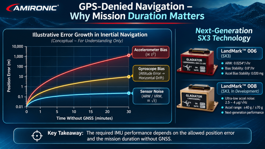
We also explore the technological evolution of Gladiator Technologies’ LandMark IMU family, from the SX2-based LandMark 005 to the next-generation SX3-based LandMark 006, and the LandMark 008 currently under development, which is designed to introduce further advances in gyroscope and accelerometer performance.
1. What Is GPS-Denied Navigation, and Why Does It Require a High-Precision IMU?
1.1 Understanding GPS-Denied Navigation
GPS-Denied Navigation refers to the ability to maintain navigation capabilities when reliable positioning information from the Global Positioning System (GPS) is unavailable.
The broader term GNSS-Denied Navigation also covers environments where other satellite navigation systems, including Galileo, GLONASS, and BeiDou, cannot provide dependable positioning information.
Under normal operating conditions, a GNSS receiver provides measurements that allow a navigation system to estimate position and velocity relative to an external reference.
When these measurements are available and trustworthy, they can be used to correct or constrain errors accumulating within an inertial navigation system.
However, when satellite signals become unavailable or unreliable, the navigation system must rely on alternative sources of motion and positioning information.
One of the most important technologies supporting this capability is inertial navigation, which estimates platform motion using angular rate and acceleration measurements.
Unlike satellite-based positioning, inertial sensing does not require continuous reception of external navigation signals.
This makes high-performance IMUs particularly valuable for defense, aerospace, autonomous vehicles, and other mission-critical applications where navigation continuity is essential.
Gladiator Technologies’ advanced MEMS IMUs are designed to provide precise, high-rate inertial measurements that can serve as a foundation for navigation, stabilization, and control systems operating under demanding conditions.
However, while inertial navigation enables continued operation without satellite signals, it cannot independently eliminate the measurement errors that accumulate over time.
1.2 How Does an Inertial Navigation System Work?
A typical six-axis IMU contains:
- Three gyroscopes, measuring angular velocity around the three measurement axes.
- Three accelerometers, measuring specific force along those axes.
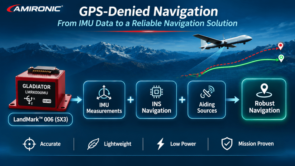
These measurements are processed by an Inertial Navigation System (INS) to estimate the platform’s motion and navigation state.
The calculation generally involves three fundamental stages.
Stage 1 – Attitude Estimation
The navigation system integrates angular rate measurements from the gyroscopes to estimate changes in platform orientation over time.
This process enables continuous tracking of attitude, including Roll, Pitch, and Yaw.
Accurate gyroscope measurements are particularly important because errors in attitude estimation can influence subsequent velocity and position calculations.
This is one of the areas where the low-noise gyroscope technology developed by Gladiator Technologies can provide significant engineering value.
Stage 2 – Velocity Estimation
Accelerometer measurements are transformed from the sensor coordinate frame into the navigation coordinate frame.
After accounting for gravity and other factors required by the navigation model, the system integrates the resulting acceleration to estimate velocity.
The accuracy of this calculation depends on both accelerometer performance and the accuracy of the estimated platform attitude.
Stage 3 – Position Estimation
The navigation system integrates the estimated velocity to calculate changes in position over time.
Unlike GNSS positioning, this calculation does not provide an independent measurement of absolute location.
Instead, the INS continuously propagates the navigation solution based on inertial measurements and known initial conditions.
The engineering implication is important: Position is not measured directly by the IMU. It is calculated through a sequence of mathematical operations that depend on sensor accuracy and initial navigation conditions.
Consequently, even small errors in angular rate or acceleration measurements can propagate through the navigation calculations and affect the overall navigation solution.
For this reason, selecting a high-performance IMU is a critical step in developing a robust inertial navigation architecture.
1.3 Why Do Gyroscope Errors Affect Position Accuracy?
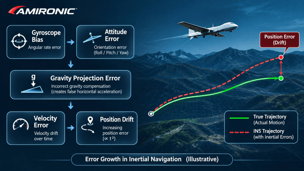
One of the most important principles of inertial navigation is the relationship between attitude accuracy and acceleration estimation.
Consider an aircraft equipped with an inertial navigation system.
If the gyroscope measurements introduce a small error in the estimated Pitch or Roll angle, the navigation system may transform the accelerometer measurements into the navigation coordinate frame using an incorrect orientation.
Because the navigation calculations must also account for gravity, even a small attitude error can cause part of the gravitational acceleration to be incorrectly interpreted as horizontal acceleration.
For example, an attitude error of just 0.1° can introduce an apparent horizontal acceleration error of approximately 0.017 m/s² due to incorrect gravity projection.
If this error remains constant for 10 seconds without external correction, it could produce approximately:
- 0.17 m/s of velocity error
- 0.85 meters of position error
This is a simplified theoretical example. It does not account for all sensor errors, platform dynamics, navigation algorithms, or potential correction mechanisms.
Nevertheless, it demonstrates a fundamental engineering principle:
Gyroscope accuracy affects more than angular measurements. It can also influence the accuracy of calculated velocity and position.
This relationship explains why improvements in gyroscope noise and bias stability are so valuable in high-performance inertial systems.
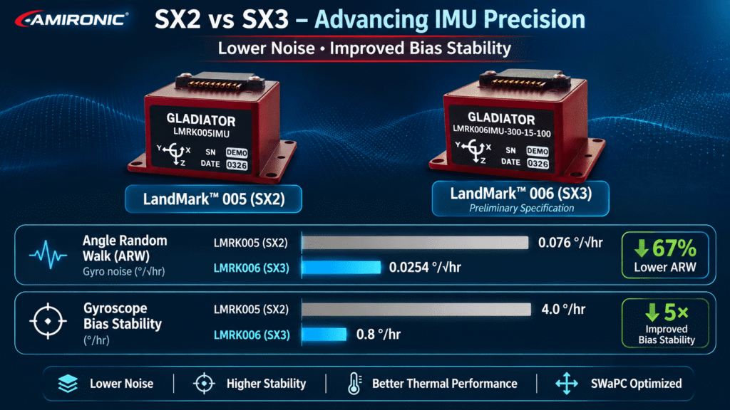
Gladiator Technologies’ transition from SX2 to SX3 technology represents an important advancement in this area, with the LandMark 006 offering substantially improved gyroscope performance compared with the earlier LandMark 005 generation.
These improvements provide system designers with a more precise inertial measurement foundation for demanding navigation and stabilization applications.
1.4 IMU vs. INS: Understanding the Difference
When designing a GPS-denied navigation system, it is essential to distinguish between two terms that are sometimes incorrectly used interchangeably.
IMU – Inertial Measurement Unit
An IMU measures angular velocity and specific force using gyroscopes and accelerometers.
Depending on the product and interface, the output may include internally calibrated, compensated, and processed measurements.
High-performance IMUs, such as Gladiator Technologies’ LandMark family, are engineered to deliver precise inertial measurements with characteristics suited to demanding navigation, stabilization, and control applications.
INS – Inertial Navigation System
An INS uses inertial measurements, known initial conditions, and navigation algorithms to estimate attitude, velocity, and position.
An INS may also integrate additional sensors or external references to correct accumulated errors and improve navigation reliability.
This distinction is particularly important when evaluating inertial products.
An IMU with excellent noise performance and bias stability can provide a strong foundation for an accurate navigation system. However, the final navigation performance also depends on the INS algorithms, initialization accuracy, sensor error models, mission conditions, and available aiding sources.
The key takeaway for system designers is clear: Selecting an IMU for GPS-denied navigation should begin with the performance requirements of the complete navigation system—not simply a comparison of individual sensor specifications.
With its continued investment in advanced MEMS technology, low-noise gyroscopes, and high-speed inertial data processing, Gladiator Technologies offers engineers a compelling range of IMU solutions for applications where precision, reliability, and navigation continuity matter.